How deep can a Ground Penetrating Radar go advice, Building subsurface check tips, Electromagnetic waves best practice
How deep can a Ground Penetrating Radar go?
15 May 2020

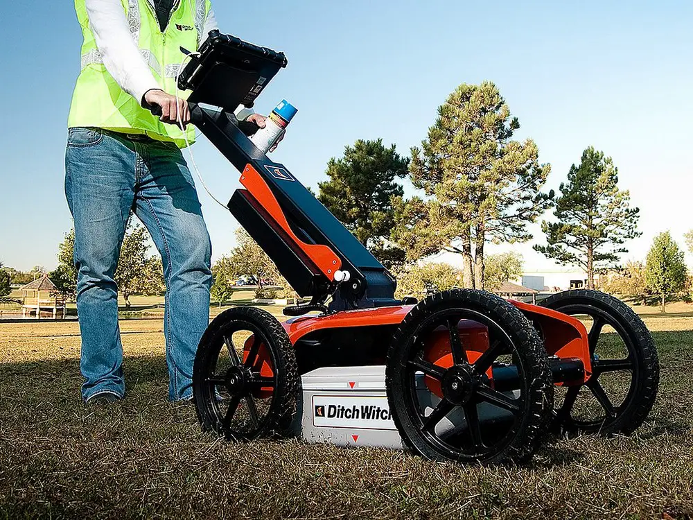
GPR Surveys use electromagnetic waves emitted from the transmitter. The waves emitted penetrate the ground and this reflects back of any materials detected. The pulses are reflected back to the gpr antenna and details the depth of the target. This two-way travel-time process takes nanoseconds to complete. The antenna is the receiver on the gpr equipment.
The permittivity of any electromagnetic properties that exist subsurface are detected by the emitted waves. The signal reflected is recorded by the gpr equipment and creates an image of the subsurface. The radargram displays the recorded data.
Ground penetrating radars are an effective way to check the conditions and the material properties of existing structures and buildings. The redargram provides an estimate of the depth and the size of the target below. This type of survey can provide added detail about subsurface structures such as measurements, dimensions and the depth which can be interpreted through the gpr data.
How deep can ground penetrating radar go – penetration depth advice
The frequency of the electromagnetic waves emitted from the antenna can be modified to change the penetration depth. Calibrating the velocity of the wavelengths is important to ensure the accuracy of the gpr data and its measurement of the depth of the materials underground.
The antenna can emit high frequency waves or low frequency waves. The design of the survey and the intended penetration depth of the ground will determine the level of frequency used. To detect materials at a greater depth lower frequency signals will be emitted by the gpr equipment. Higher frequency signals will emit a stronger signal but it will not travel as far or penetrate as deep underground. The strength of the signal can improve the accuracy of the gpr data. However, to reach a greater penetration depth the signal needs to be at a lower frequency. The disadvantage of this is that the signal is more likely to scatter and this can affect the accuracy of the data. Although, it is still an effective way to measure the depth of electromagnetic materials subsurface.
The frequency of the ground penetrating radar can vary from 1 to 1000 MHz and can penetrate the ground to a depth of 100 feet. The density of the target is transmitted back to the receiver.
The depth that the ground penetrating radar can reach is dependent upon the location of the site and the environment where the survey is being completed. The environment of the ground above surface must be clear of debris to ensure that the antenna is close enough to the ground. The type of soil or materials that exist in the subsurface layers can weaken the frequency of the signal and this can undermine the penetration depth of the radar.
The site conditions, the characteristics of the target and the antenna frequency are all variables which can affect the penetration depth of the ground penetrating radar.
What can ground penetrating radar detect?
The ground penetrating radar can detect materials that hold different electromagnetic properties than the environment that surrounds them. The greater the difference in the detected material properties, the stronger the reflection of electromagnetic energy will be. The way in which the gpr can be wheeled around the survey site means that data can be produced over a vast area of land. Ground penetrating radar’s can be applied to soil, rock, ice, water, pavement and concrete structures.
Ground penetrating radars detect plastics, metals and concrete. The equipment is used in construction and utility locating. It is also used by geologists who detect any changes in the strata underground and bedrock whilst archeologists penetrate the ground prior to excavation in search for buried objects. The non-destructive way in which the ground penetrating systems can locate objects underground is especially important for archeologist when searching for artefacts.
In construction, ground penetrating radars are imperative to detect the underground voids or sinkholes/ subsistences. Voids and sink holes can be dangerous when moving machinery or using equipment. The detection of these ensures that the landscape remains a safe environment for people to work in. Ground penetrating radars are an efficient and cost-effective way to detect aforesaid weaknesses in the landscape.
Ground penetrating radars are effective for locating utilities in the ground. The subsurface mapping by the radar signal can produce a clear image of where utility lines and pipes lines exist underground. In public places and on project sites, this can be an efficient and safer way to make sure no unnecessary damage is created such as digging into an essential pipelines for example.
The main environment in which ground penetrating radar’s do not work most effectively in are waterlogged subsurfaces. The signal is not as strong in these environments, the results of which would likely impact the data and negatively impact the outcome of the survey.
Can ground penetrating radar can see through concrete?
The non-destruction nature of the gpr system means that the radar can test concrete structures without the need to physically investigate or disturb the environment the concrete exists underneath of. For concrete, the maximum penetration of the gpr is 2 feet.
Ground penetrating radars can be used to locate the material subsurfaces and it can detect any voids that exist inside the concrete which may aggravate the structure it pertains to. Through interpretation of gpr data, it can highlight any areas of deterioration or corrosion of steel reinforcements that exist inside the concrete structure and is an effective way to determine if any parts need repaired or replaced. The material properties of steel changes as the corrosion worsens. The gpr signal slows down and take longer to reflect of the corroded surface inside the unaffected concrete. Hence, the ground penetrating radar is an efficient way to detect material damage within the concrete structure.
GPR data can be used to ensure the stability and structural integrity of concrete structures without disturbing the foundation of the construction site. By using the ground penetrating radar, drilling into the concrete is avoided as well as the high costs this would demand. By using the gpr equipment, any risks or harm that those working on the site could encounter by cutting into the concrete structure is equally avoided.
Penetrating radars are commonly used to test for any civil engineering issues. For example the radar can detect any cables, wiring or conduits within the concrete structure which could have been damaged if invasive action was taken.
GPR is similarly used to survey the layer interface of roads and to assess pavements too. This is in order to check for voids as well as moisture underground.
Ground penetrating radars can see through concrete. However, there are natural variables and conditions that differ from every survey site that can determine the success of this and affect the data collated. There are no two survey sites which are identical hence an element of trial and error is involved to determine how strong the electromagnetic properties of the target are. The strength of this will determine the accuracy of the reflected signal providing a more accurate reading of the depth of the material subsurface.
How much does ground penetrating radar cost?
Ground penetrating radars are expensive pieces of equipment. Some companies sell them outright and the price varies between £10,000 to upwards of £15,000 approximately.
Ground penetrating equipment is commercially available to lease. If the equipment is rented, then the price can be dependent upon the size of the project and the length of time the user intends to use it for. There may be a mobilisation fee included in order to get the equipment to the survey site safely. Some companies provide project managers who are specialists in using the equipment which is useful if the gpr systems is unfamiliar to those completing the survey.
If users are inexperienced in reading the gpr data then hiring a specialist who is experienced in interpreting it may be an added cost to be aware of. Initial reading of the data can be done on site. However, the data may need to be sent away for further review afterwards.
Can sonar penetrate the ground?
Sonar penetration of ground involves an acoustic device which can penetrate about a foot below the subsurface. The device can locate structures underground through the transmitted acoustic signals and the acoustic energy that this produces whilst directed towards the ground.
High frequency acoustic pulses penetrate the ground and the sound reflects of the subsurface materials. The sound may scatter similar to the radar but there are ways of containing this. The length of the wavelength and the velocity of this can determine the resolution of the data. Trial and error of these two components will be necessary to locate the target. In scientific studies about transmitted acoustic signals, the frequency and shape of the acoustic pulse was modified similar to the ground penetrating radar as the frequency also affected the length that the acoustic pulse would travel.
Comments on the How To Check Your Roofs’ Guttering For Wearing advice article welcome
Major Scottish Buildings
Key Buildings in Scotland Articles – architectural selection below:
Historic Glasgow : best Glasgow architecture of the past
New Chryston community hub building
image courtesy of architects practice
Chryston Community Hub in North Lanarkshire
Comments / photos for the How To Check Your Roofs’ Guttering For Wearing Tips page welcome.